Wednesday, 21 January 2015

Minecraft Hoenn: Part 32/43: Route 126

Part 32/43 of the creation of the Hoenn Region in Minecraft.

Oh it's been 10 days already. But as I've said before good work takes time. And this time it's route 126. This route uses some sandstone rocks that surround what will soon be Sootopolis City. Sootopolis City is in the centre of Route 126, or will be in the next update. But the end result is here and as always it looks fantastic.


ROUTE 126
(Image sourced from Bulbapedia)

Route 126 can be accessed from route 127 to the east or route 124 to the north. According to the map description on the Gameboy game it would take a swimmer 'three entire days' to swim a lap around the volcano that houses Sootopolis City. Route 126 is the same size as route 127, 160x160 blocks.

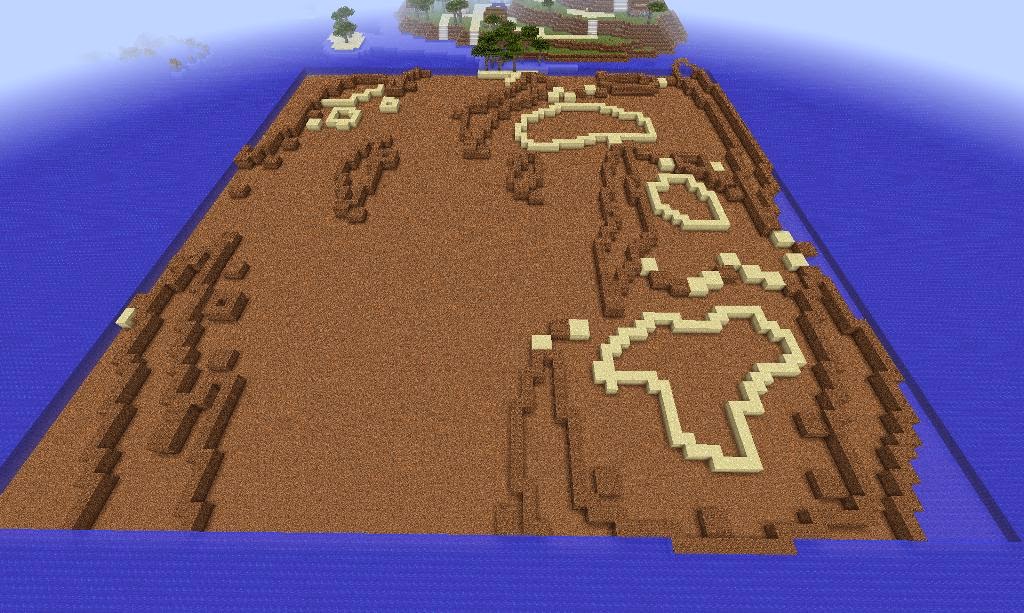
There's not really much to write about at most of the screenshots are self explanatory. Are they? Actually, all the big rocks are built at a 1 block higher level than everything else so the top layer can be cloned up one block later on to save time.

On the ground it gives you an idea of what a dry ocean would look like.


UNDERWATER
(Image sourced from Bulbapedia)

The underwater area provides a place (in the Gameboy game) to catch some Pokemon that can't be caught on the water surface. Most underwater construction was done using MCEdit. Why? Well on the Gameboy game you move the character a set amount of times, for example 6 times. You multiply that by 2 (because it's 2:1 scale) and then you can set that exact amount of blocks to remove in MCEdit. This significantly reduces the change of human error.


There are several underwater areas some linking to another.


While excavating the underground area I got a bit distracted and continued working on the above ground rocks.


Scooping out the rest of the dirt to make way for the 'seaweed'.

The 'seaweed' it actually spruce leaves. They most resemble seaweed so they are being used as seaweed.

More dried out ocean.

Some of you who have downloaded the preview may have noticed that this rock face was missing. Why? Well when building Mossdeep city it was too far away to be placed with any reliable reference points.

But now that there are reliable reference points I can easily build it.

Like before when I did the rock faces I used MCEdit to do everything you see below.

But finishing the job employed a less high tech solution,

Before flooding with water.

Finished flooding with water and finishing the route.

FINISHED PRODUCT

Route 126 and 127 with Mossdeep City in the fog.

Underwater area.

Rocks with Mossdeep City in the background.


I think this screenshot is the best so far. Once the project is finished all the screenshots on http://www.planetminecraft.com/ will get replaced by screenshots of the spectacular finished project.

OH, AND THIS...
1,000 views. Mostly from the USA. It seems though that the monthly viewing statistics almost double every month.

Progress so far...


Stay tuned and subscribe.
PS: Check this project out on Planet Minecraft.

Or you can now download a preview here:

If you have any tips for improvement please don't hesitate to share. It would be greatly appreciated. Next: Part 33 features Sootopolis City and the Cave of Origin.
After That: Part 34 features Route 128.
And After That: Part 35 features Route 129 and Route 130.
73% Complete.

Sunday, 11 January 2015

Minecraft Hoenn: Part 31/43: Route 127

Part 31/43 of the creation of the Hoenn Region in Minecraft.

Part 31 and the first post of 2015. I've been on holidays which will explain why it too a while to post another update. But here is it. Route 127. A water route that provides a means of access to Sootopolis City and Ever Grande city from Mossdeep City. 90% of this route was made with an external world editor to save time and for accuracy as you can place a set amount of blocks instantly and easily.


(Image sourced from Bulbapedia)

So, Route 127. There aren't any landmarks but there is a quite interesting and quite deep underwater area. It's quite a large route but it is not the largest in Hoenn. That record belongs to route 124. Route 127 though is still pretty big though.

160x160 blocks. First thing I like to do when building a water route is pump all the water out. This makes it so much easier to build the route as no water is going to get in the way. Working underwater blocks out light, slows down walking speed and when using an external world editor, easier to select non-water blocks such as dirt. 

A small bit of Mossdeep City pokes into the boundaries because at the time of making Mossdeep City I thought it would be easier to include this bit now so that I won't have to do it later.

The rocks are very important and take a lot of effort to get accurate. To get the measurements you count the steps you take along the rock face one at a time. Multiply it by 2. And then using a world editor put that amount of blocks into the area they need to go. It's time consuming but well worth it.

Again, reference points are priceless when reconstructing something. Line up a rock face with the next, mark it and then double check. Always double check, even if you think you have it right. Having even one block out of alignment can mess things up further down the line.

Gravel as filler. Only use gravel if you are certain that you wont be building anything underneath or you will have a very messy job ahead. 

Well, that's the rocks complete. Coarse dirt of course as grass or mycelium will not grow and spoil the look. 

Some sandy islands. The same building principal applies here. Count steps, multiply by 2 (unless you were counting by twos) and then put the correct amount of sand in the correct place.

UNDERWATER
The underwater area. Thank goodness that it lines up perfectly with the over world otherwise who know the amount of problems we will have.


All was done with the external world editor and all was done with the same building principles. Except we're removing material. 

And in just 3 hours (ugh!) the excavation is done. 

On the ground when it's all dried up it looks like a dirt canyon. 


A small tunnel on the eastern side. 

Using the external world editor replace all air blocks from sea level down with water. Doing this turns it into an actual water route.

I just love how natural it looks without any tweaks especially the underwater canyon. It looks brilliant. 

FINISHED PRODUCT
Ariel view. 

Looking from the Mossdeep Space Centre. 

A boat ride over the underwater canyon. 


The underwater canyon (with the aid of a night vision potion). 


Looking west from a tree island. 

Progress so far. 


Stay tuned and subscribe.
PS: Check this project out on Planet Minecraft.

Or you can now download a preview here:

If you have any tips for improvement please don't hesitate to share. It would be greatly appreciated. Next: Part 32 features Route 126.
After That: Part 33 features Sootopolis City and the Cave of Origin.
And After That: Part 34 features Route 128.
70% Complete.